GIS / Mapping
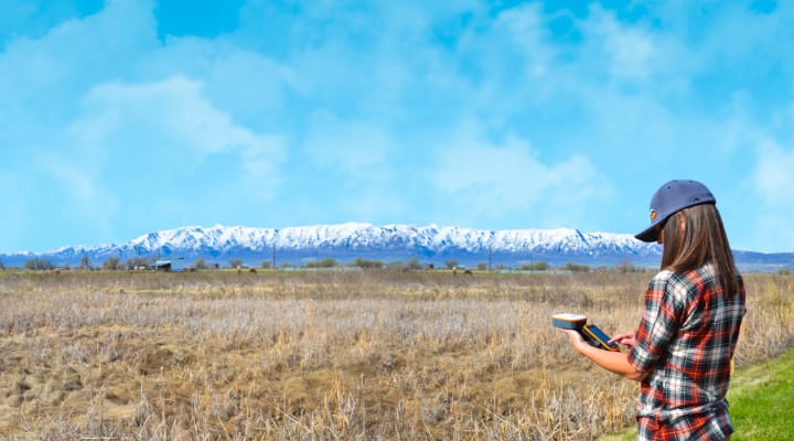
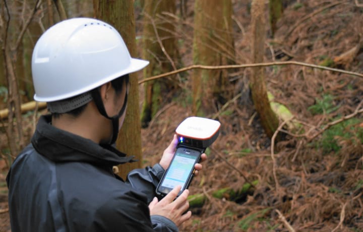
Geode:Sub-Meter GNSS receiver
Compact and simple Real-Time Sub-Meter accuracy GNSS receiver.
Sub-Meter accuracy
By combining a handheld device and Geode, you can easily acquire GNSS data with submeter accuracy.
Affordable
You might think that a GNSS receiver with submeter accuracy is expensive…
Get the professional accuracy you need at a budget-friendly price.
Compact size
Small and lightweight, Geode offers an all-in-one GNSS solution.
Various combinations
Attached to a pole for surveying, attached to a handheld for mapping, and attached to a magnet mount for in-vehicle use.
It is a highly flexible GNSS receiver that can be operated in various ways according to the purpose.
Open interface
Connect GNSS data with submeter accuracy to your Windows device or Android / iOS device via Bluetooth.
Juniper Rugged quality
Achieves the highest class IP68 of waterproof and dustproof performance. It has a battery performance of 10 hours or more that enables continuous work during the day, improving work efficiency.
In addition, the manufacturer’s warranty is 2 years as standard. We also have an additional warranty plan of up to 5 years.
Application
- Mapping and navigation in the forestry
- Field measurement
- Equipment mapping / navigation
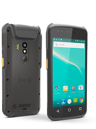
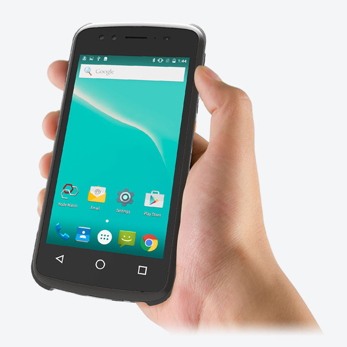
G47:A mobile device with compact, lightweight and ruggedness.
An industrial-grade Android device, lightweight and ruggedness design for everyday use works perfectly in field applications.
Specifications
- Octa (8) core processor & Android 11
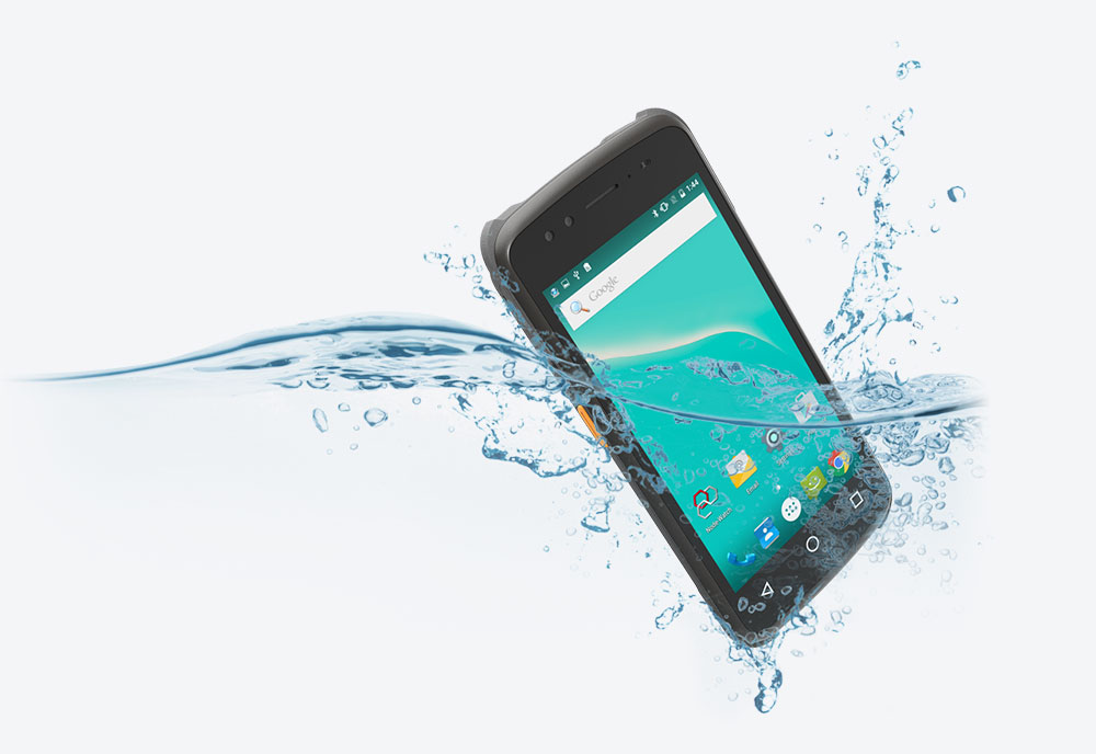
- Waterproof & Ruggedness performance IP67 design
- High security with fingerprint authentication lock
- High-performance GNSS module (GPS / GLONASS / BeiDou / QZSS compatible)
- Equipped with various sensors such as electronic compass, accelerometer, gyro, etc. Equipped with many sensors, compatible with various applications
- 243g ultra-lightweight design and compact for field work
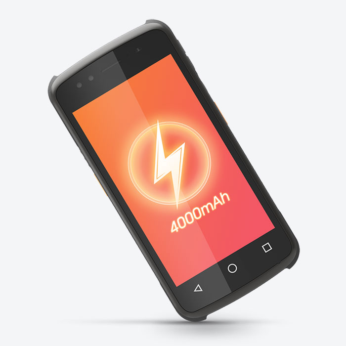
- Supports long battery life / quick charging Equipped with a battery that can be fully charged in about 1 hour to 1.5 hours with an operating time of about 10 hours that can handle daily work
- Glove touch display
Application
- Fieldwork (Survey, Mapping, Civil construction)
- Warehouse
- Factory
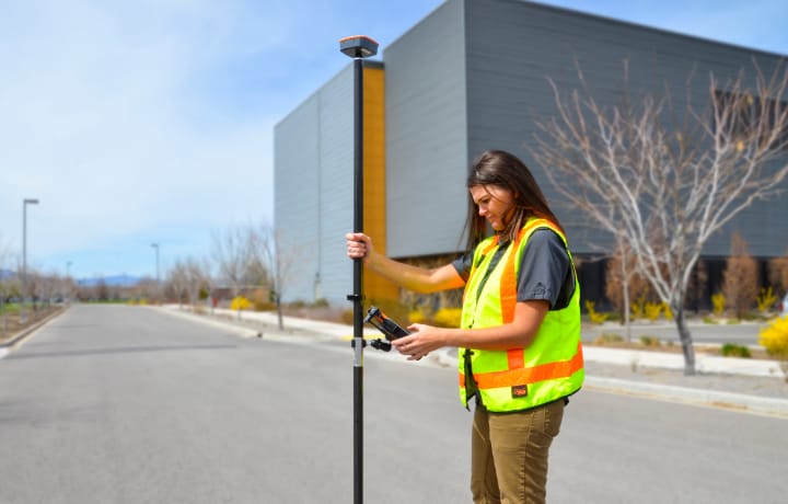
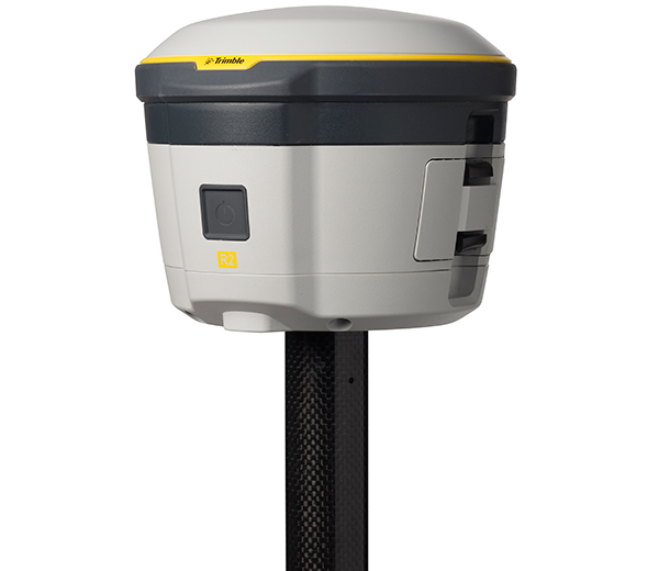
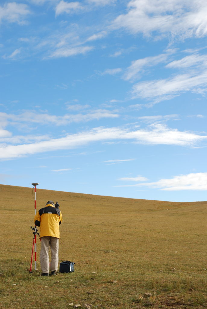
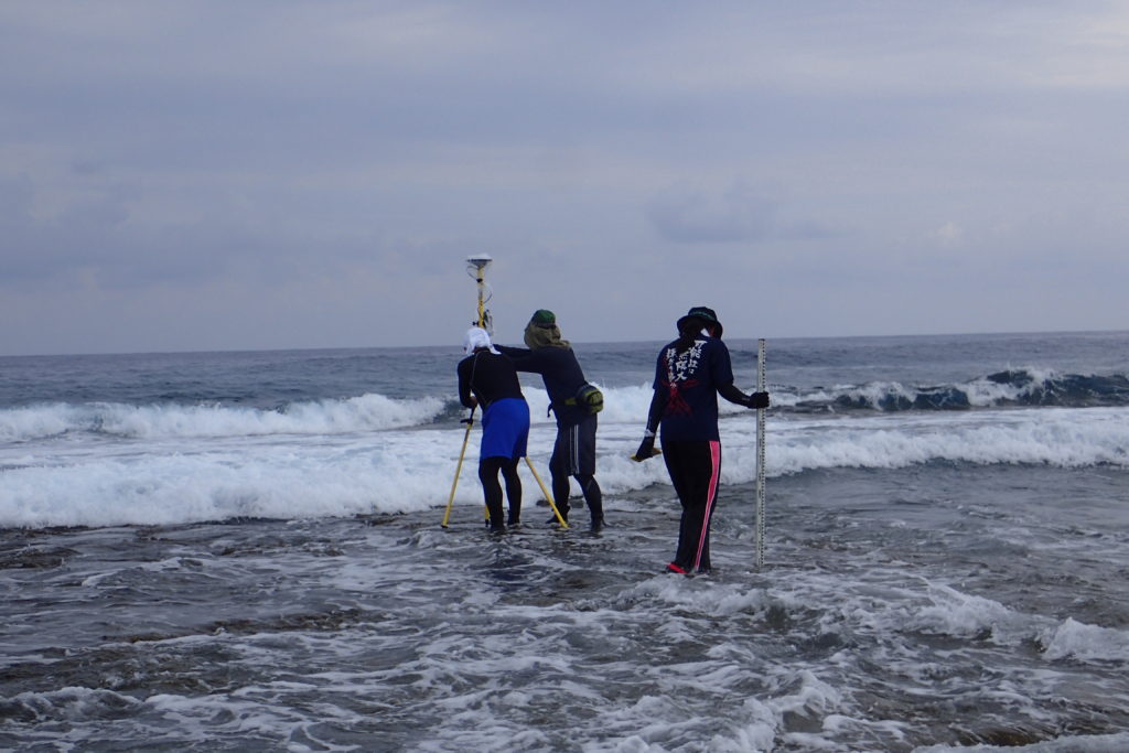
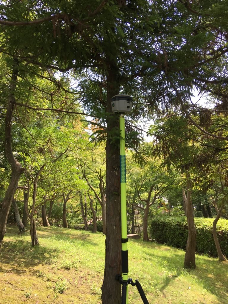
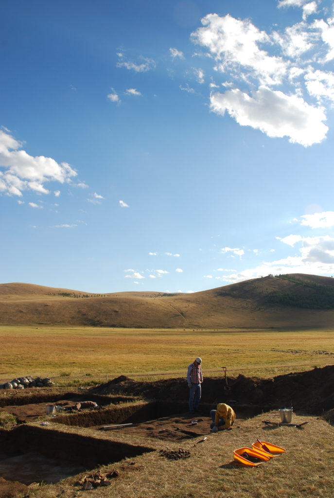
R2 GNSS:High precision surveying system package
We have a lineup of packages according to applications, from cost-effective post-processing surveying packages to VRS surveying packages that realize high-precision surveying in real time. Although it is not a public survey, it is a survey system package that meets the needs for high-precision surveying. Since the controller for data capturing is an Android device, it has excellent operability and anyone can easily survey. In overseas surveying, it is difficult to obtain the coordinates of the reference station, so it is difficult to measure the absolute coordinates.
The CenterPoint RTX Post-Processing service can be used effectively in such cases.
This solution is a free post-processing service provided by Trimble, and provides coordinates with a horizontal accuracy of 2 cm or less anywhere in the world.
Application
- Archaeological survey
- Topography measurement (coastal erosion, faults, tsunami traces, glacial landforms)
- GCP survey
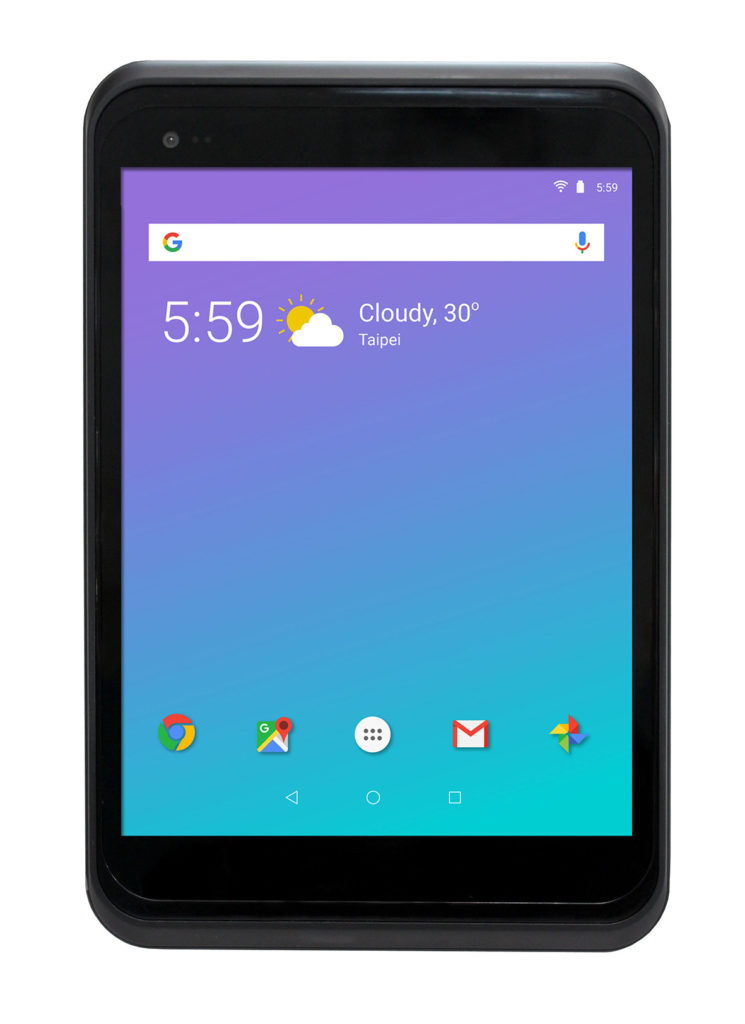
GT78:Commercial tablet designed for outdoor use
A rugged 8-inch tablet designed for all harsh environments.
The tablet GT78 you need for your business anytime, anywhere. With performance that meets the needs of the field, the ultra-thin 1D / 2D barcode scanner provides fast scanning speed, and the GT78 streamlines operations. In addition, by installing Android OS, you can use apps that suit your business. We also develop business applications, so please be assured that we will offer total proposals from hardware to software, and support after installation.
Application
- Fieldwork (Survey, Mapping, Civil construction)
- Warehouse
- Factory
- Distribution (vehicle operation management)
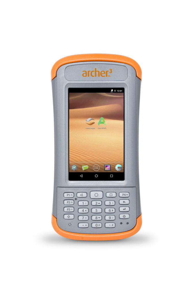
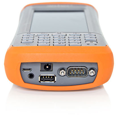
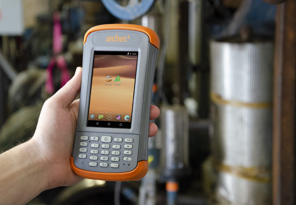
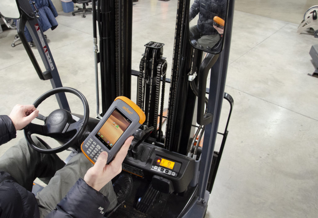
Archer3:The ultimate handheld designed to work to the end
Archer3 is the ultimate ultra-rugged handheld device with one-handed input. Not only touch panel operation but also keypad input is possible, so you can operate with one hand. In addition, RS232 serial port and USB host / client are prepared, and it also supports conventional wired data communication. Equipped with the highest class IP68 waterproof and ruggedness performance, a battery that can operate for 20 hours, it is a performance that can be used in any environment. In addition, the Archer 3 assembled in the United States is a first-class product in terms of quality.
Application
- Fieldwork (Survey, Mapping, Civil construction)
- Warehouse
- Factory
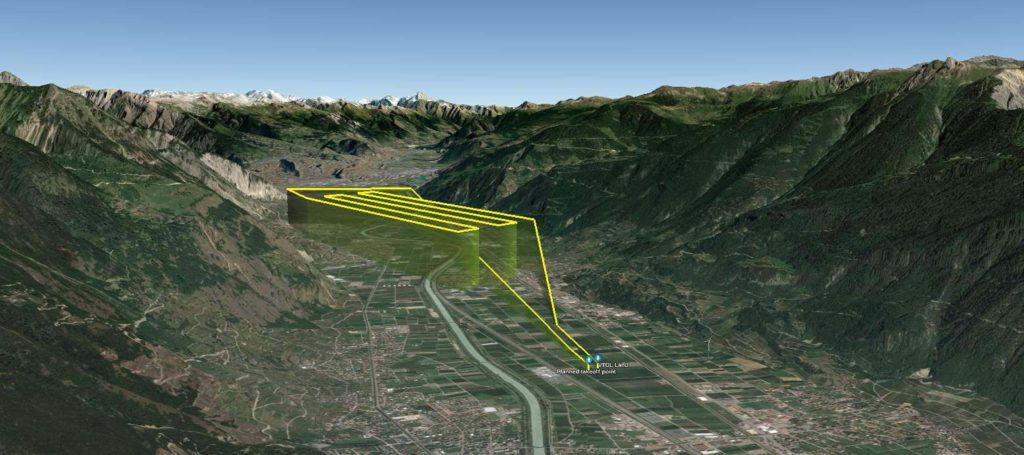
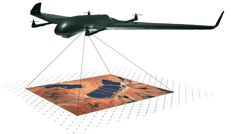
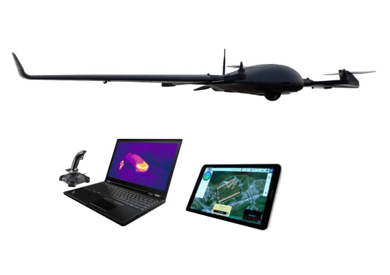
DeltaQuad:VTOL drone for flight anywhere

The DeltaQuad Pro is one of the few autonomous vertical takeoff and landing fixed-wing UAVs. Fixed-wing UAV flights require a certain amount of space for takeoff and landing, however the Delta Quad is a fixed-wing UAV, it can take off and land vertically like a helicopter, and can fly anywhere. Especially during disaster investigations, fixed-wing UAVs are required to capture a wide area, however takeoff and landing sites cannot be secured. Multi-rotorcraft UAVs have a narrow shooting range, require multiple flights, and are inefficient. DeltaQuad Pro is an cutting edge UAV (drone) system that can meet both of these requirements.
The DeltaQuad Pro VTOL UAV is available in the following models
- DeltaQuad Pro #CARGO
Versatile VTOL UAV for transport or custom sensor integration - DeltaQuad Pro #VIEW
VTOL Surveillance UAV Thermal & RGB HD live video - DeltaQuad Pro #MAP
For fully automatic mapping (MicaSense sensor can be installed) - DeltaQuad Pro #INSPECT
For utilities, wildlife surveys, disaster inspections (FLIR heat sensor camera can be installed)
Application
- Archaeological survey
- Civil construction survey
- Terrain survey
- Disaster investigation
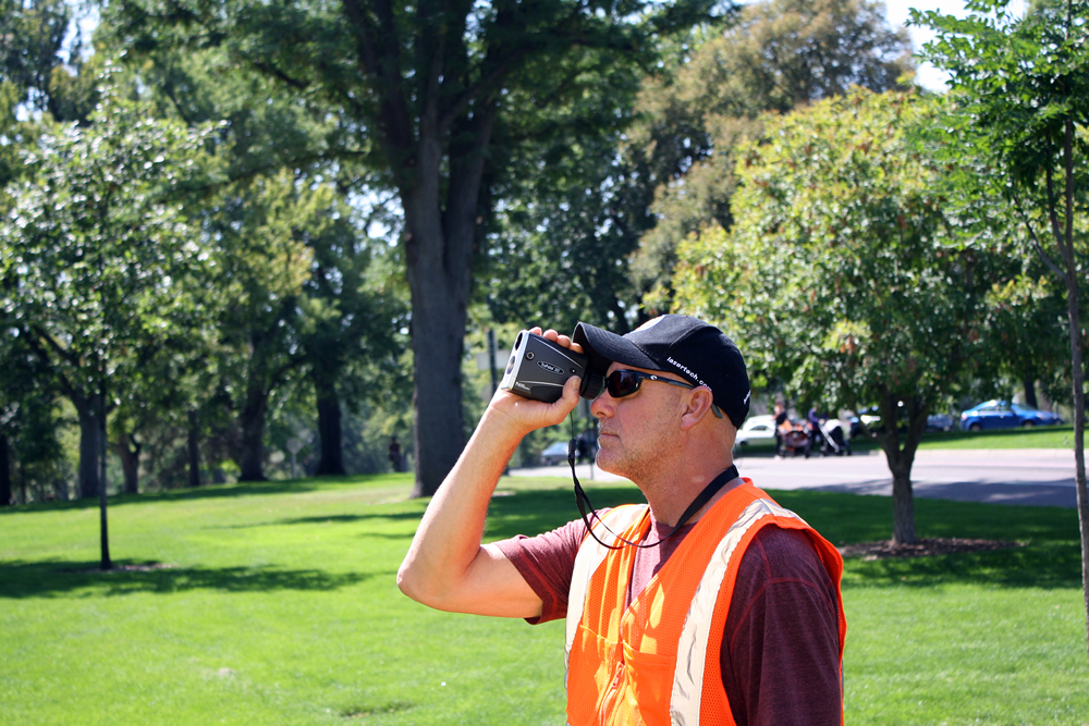
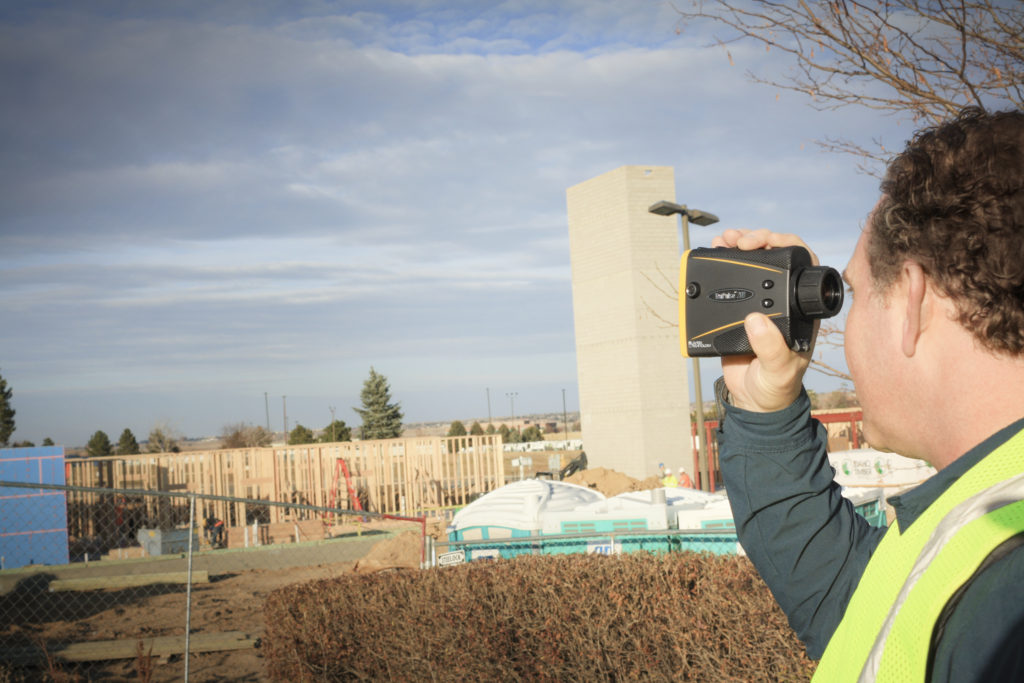
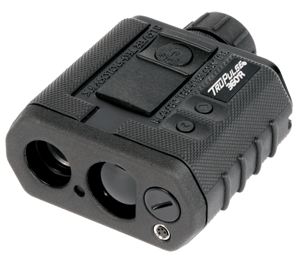
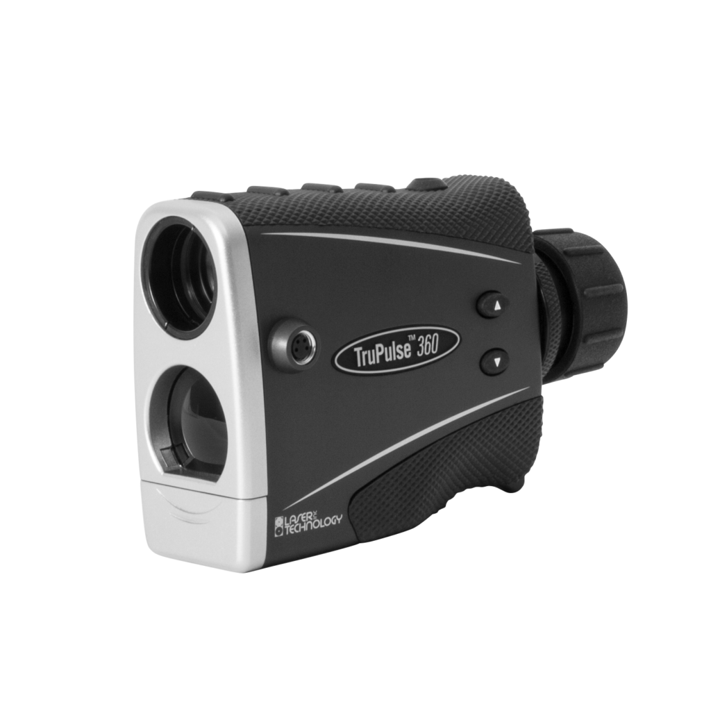
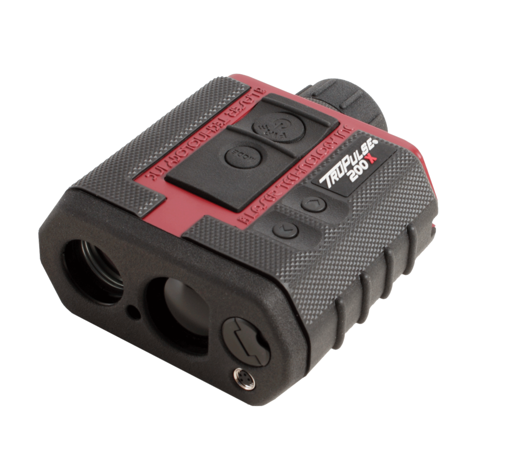
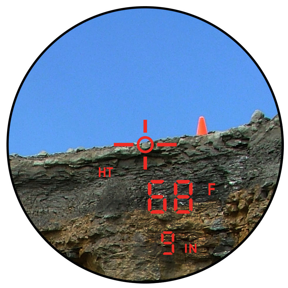
TruPulse:Handheld laser rangefinder with built-in compass
The compact TruPulse 360 series with a built-in compass is the one and only handhld laser rangefinder. With TruPulse360, you can measure azimuth and distance at the same time for compass surveying.
The TruPulse series is a rangefinder for professional applications with a diverse product lineup from the entry model TruPulse200L to the professional model TruPulse200X and 360R. In addition, TruPulse is equipped with a tilt sensor, so it can measure ① slope distance, ② vertical distance, ③ horizontal distance, ④ inclination, and ⑤ height of the target with one-touch measurement. In the vertical spacing measurement mode, you can measure ⑥ vertical spacing slope distance, ⑦ height difference, ⑧ vertical spacing horizontal distance, and ⑨ inclination just by measuring two points top and bottom.
TruPulse 360 Series has an integrated compass that allows you to measure azimuth which enhances the Missing Line routine. This is a simple 2-shot routine that instantly calculates the distance, inclination and azimuth direction value between any two remote points. For measurement in the forest, by using a special filter, only the reflector can be captured, enabling laser measurement in deep canopy environments.
Application
- Mapping
- Surveying
- Research
- Civil construction
- Equipment inspection
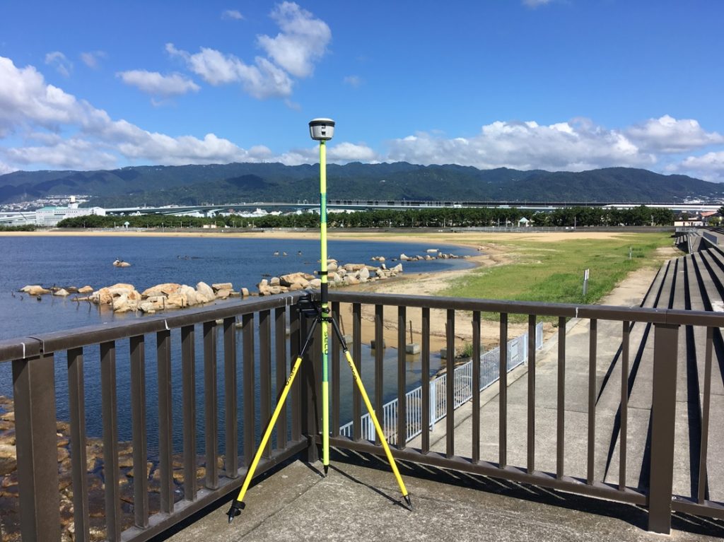
Surveying
Easy realization of high-precision surveying
AGILE GEO DESIGN CORPORATION provides a surveying system to easily realize high-precision surveying. We can propose from the VRS system package that performs high-precision surveying in real time to the high-precision post-processing baseline analysis package by post-processing. It is a system that has been introduced in many fields such as topographic surveys, archaeological surveys, and GCP (Ground Control Point) as well as general surveying applications.
R2 GNSS:High precision surveying system package
We have a lineup of packages according to applications, from cost-effective post-processing surveying packages to VRS surveying packages that realize high-precision surveying in real time. Although it is not a public survey, it is a survey system package that meets the needs for high-precision surveying. Since the controller for data capturing is an Android device, it has excellent operability and anyone can easily survey. In overseas surveying, it is difficult to obtain the coordinates of the reference station, so it is difficult to measure the absolute coordinates.
The CenterPoint RTX Post-Processing service can be used effectively in such cases.
This solution is a free post-processing service provided by Trimble, and provides coordinates with a horizontal accuracy of 2 cm or less anywhere in the world.
Application
- Archaeological survey
- Topography measurement (coastal erosion, faults, tsunami traces, glacial landforms)
- GCP survey
G47:A mobile device with compact, lightweight and ruggedness.
An industrial-grade Android device, lightweight and ruggedness design for everyday use works perfectly in field applications.
Specifications
- Octa (8) core processor & Android 11
- Waterproof & Ruggedness performance IP67 design
- High security with fingerprint authentication lock
- High-performance GNSS module (GPS / GLONASS / BeiDou / QZSS compatible)
- Equipped with various sensors such as electronic compass, accelerometer, gyro, etc. Equipped with many sensors, compatible with various applications
- 243g ultra-lightweight design and compact for field work
- Supports long battery life / quick charging Equipped with a battery that can be fully charged in about 1 hour to 1.5 hours with an operating time of about 10 hours that can handle daily work
- Glove touch display
Application
- Fieldwork (Survey, Mapping, Civil construction)
- Warehouse
- Factory
Archer3:The ultimate handheld designed to work to the end
Archer3 is the ultimate ultra-rugged handheld device with one-handed input. Not only touch panel operation but also keypad input is possible, so you can operate with one hand. In addition, RS232 serial port and USB host / client are prepared, and it also supports conventional wired data communication. Equipped with the highest class IP68 waterproof and ruggedness performance, a battery that can operate for 20 hours, it is a performance that can be used in any environment. In addition, the Archer 3 assembled in the United States is a first-class product in terms of quality.
Application
- Fieldwork (Survey, Mapping, Civil construction)
- Warehouse
- Factory
GT78:Commercial tablet designed for outdoor use
A rugged 8-inch tablet designed for all harsh environments.
The tablet GT78 you need for your business anytime, anywhere. With performance that meets the needs of the field, the ultra-thin 1D / 2D barcode scanner provides fast scanning speed, and the GT78 streamlines operations. In addition, by installing Android OS, you can use apps that suit your business. We also develop business applications, so please be assured that we will offer total proposals from hardware to software, and support after installation.
Application
- Fieldwork (Survey, Mapping, Civil construction)
- Warehouse
- Factory
- Distribution (vehicle operation management)
Geode:Sub-Meter GNSS receiver
Compact and simple Real-Time Sub-Meter accuracy GNSS receiver.
Sub-Meter accuracy
By combining a handheld device and Geode, you can easily acquire GNSS data with submeter accuracy.
Affordable
You might think that a GNSS receiver with submeter accuracy is expensive…
Get the professional accuracy you need at a budget-friendly price.
Compact size
Small and lightweight, Geode offers an all-in-one GNSS solution.
Various combinations
Attached to a pole for surveying, attached to a handheld for mapping, and attached to a magnet mount for in-vehicle use.
It is a highly flexible GNSS receiver that can be operated in various ways according to the purpose.
Open interface
Connect GNSS data with submeter accuracy to your Windows device or Android / iOS device via Bluetooth.
Juniper Rugged quality
Achieves the highest class IP68 of waterproof and dustproof performance. It has a battery performance of 10 hours or more that enables continuous work during the day, improving work efficiency.
In addition, the manufacturer’s warranty is 2 years as standard. We also have an additional warranty plan of up to 5 years.
Application
- Mapping and navigation in the forestry
- Field measurement
- Equipment mapping / navigation
DeltaQuad:VTOL drone for flight anywhere
The DeltaQuad Pro is one of the few autonomous vertical takeoff and landing fixed-wing UAVs. Fixed-wing UAV flights require a certain amount of space for takeoff and landing, however the Delta Quad is a fixed-wing UAV, it can take off and land vertically like a helicopter, and can fly anywhere. Especially during disaster investigations, fixed-wing UAVs are required to capture a wide area, however takeoff and landing sites cannot be secured. Multi-rotorcraft UAVs have a narrow shooting range, require multiple flights, and are inefficient. DeltaQuad Pro is an cutting edge UAV (drone) system that can meet both of these requirements.
The DeltaQuad Pro VTOL UAV is available in the following models
- DeltaQuad Pro #CARGO
Versatile VTOL UAV for transport or custom sensor integration - DeltaQuad Pro #VIEW
VTOL Surveillance UAV Thermal & RGB HD live video - DeltaQuad Pro #MAP
For fully automatic mapping (MicaSense sensor can be installed) - DeltaQuad Pro #INSPECT
For utilities, wildlife surveys, disaster inspections (FLIR heat sensor camera can be installed)
Application
- Archaeological survey
- Civil construction survey
- Terrain survey
- Disaster investigation
TruPulse:Handheld laser rangefinder with built-in compass
The compact TruPulse 360 series with a built-in compass is the one and only handhld laser rangefinder. With TruPulse360, you can measure azimuth and distance at the same time for compass surveying.
The TruPulse series is a rangefinder for professional applications with a diverse product lineup from the entry model TruPulse200L to the professional model TruPulse200X and 360R. In addition, TruPulse is equipped with a tilt sensor, so it can measure ① slope distance, ② vertical distance, ③ horizontal distance, ④ inclination, and ⑤ height of the target with one-touch measurement. In the vertical spacing measurement mode, you can measure ⑥ vertical spacing slope distance, ⑦ height difference, ⑧ vertical spacing horizontal distance, and ⑨ inclination just by measuring two points top and bottom.
TruPulse 360 Series has an integrated compass that allows you to measure azimuth which enhances the Missing Line routine. This is a simple 2-shot routine that instantly calculates the distance, inclination and azimuth direction value between any two remote points. For measurement in the forest, by using a special filter, only the reflector can be captured, enabling laser measurement in deep canopy environments.
Application
- Mapping
- Surveying
- Research
- Civil construction
- Equipment inspection
Civil construction
Providing total solutions for civil construction
We are engaged in system development and consulting for civil construction. AGILE GEO DESIGN CORPORATION can propose a system that meets the needs of the site, from hardware to software. In addition, in collaboration with our partners, we also support the introduction, installation and support of guidance systems that support i-Construction. Furthermore, we provide cutting edge civil construction solutions using 3D design data creation and AR / VR.

Polynav2000P/B:RTK GNSS/INS Sensor
Polynav2000P is for GNSS rover which is integrated IMU. It is not only high precision positioning and also can be detected attitude(pitch, roll and yaw). It can be used wide range of application as a sensor.
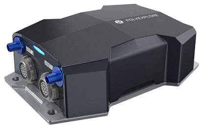
Polynav2000B is most simple easy to use GNSS base receiver. Polynav2000B has a function of Ntrip server configuration, therefore, you can start the correction data deliver service by Ntrip easily by connecting internet.
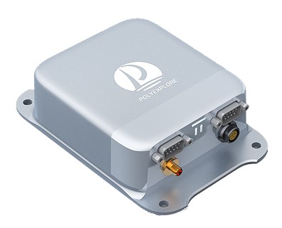
Application
- Heavy machinery for civil construction
- GNSS surveying
- GNSS sensor
- Correction service
R2 GNSS:High precision surveying system package
We have a lineup of packages according to applications, from cost-effective post-processing surveying packages to VRS surveying packages that realize high-precision surveying in real time. Although it is not a public survey, it is a survey system package that meets the needs for high-precision surveying. Since the controller for data capturing is an Android device, it has excellent operability and anyone can easily survey. In overseas surveying, it is difficult to obtain the coordinates of the reference station, so it is difficult to measure the absolute coordinates.
The CenterPoint RTX Post-Processing service can be used effectively in such cases.
This solution is a free post-processing service provided by Trimble, and provides coordinates with a horizontal accuracy of 2 cm or less anywhere in the world.
Application
- Archaeological survey
- Topography measurement (coastal erosion, faults, tsunami traces, glacial landforms)
- GCP survey
DeltaQuad:VTOL drone for flight anywhere
The DeltaQuad Pro is one of the few autonomous vertical takeoff and landing fixed-wing UAVs. Fixed-wing UAV flights require a certain amount of space for takeoff and landing, however the Delta Quad is a fixed-wing UAV, it can take off and land vertically like a helicopter, and can fly anywhere. Especially during disaster investigations, fixed-wing UAVs are required to capture a wide area, however takeoff and landing sites cannot be secured. Multi-rotorcraft UAVs have a narrow shooting range, require multiple flights, and are inefficient. DeltaQuad Pro is an cutting edge UAV (drone) system that can meet both of these requirements.
The DeltaQuad Pro VTOL UAV is available in the following models
- DeltaQuad Pro #CARGO
Versatile VTOL UAV for transport or custom sensor integration - DeltaQuad Pro #VIEW
VTOL Surveillance UAV Thermal & RGB HD live video - DeltaQuad Pro #MAP
For fully automatic mapping (MicaSense sensor can be installed) - DeltaQuad Pro #INSPECT
For utilities, wildlife surveys, disaster inspections (FLIR heat sensor camera can be installed)
Application
- Archaeological survey
- Civil construction survey
- Terrain survey
- Disaster investigation
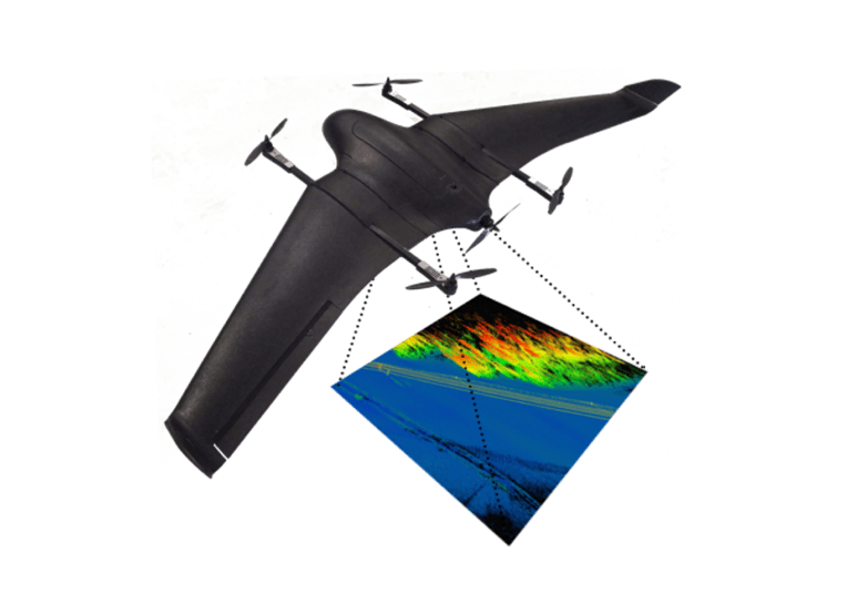
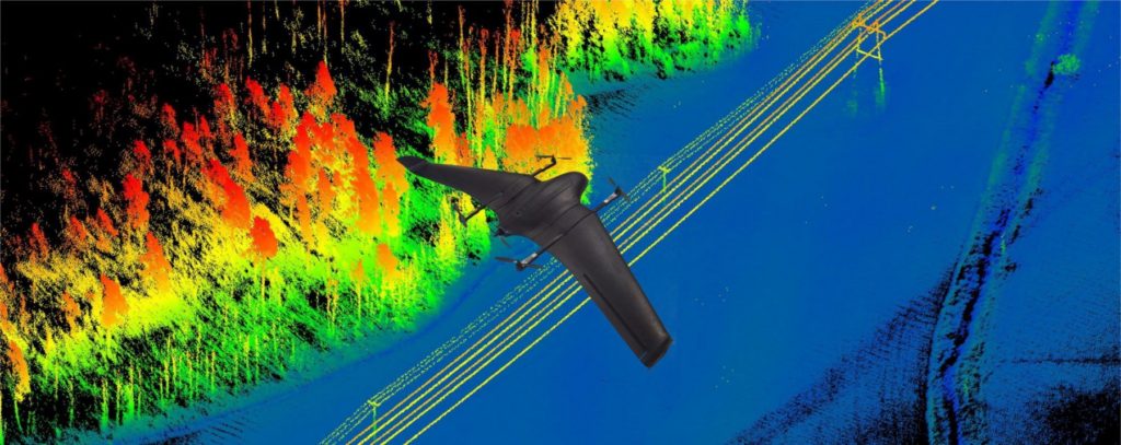
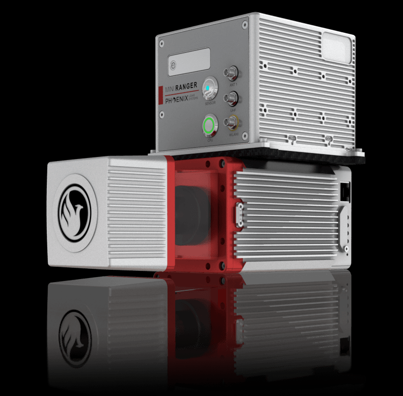
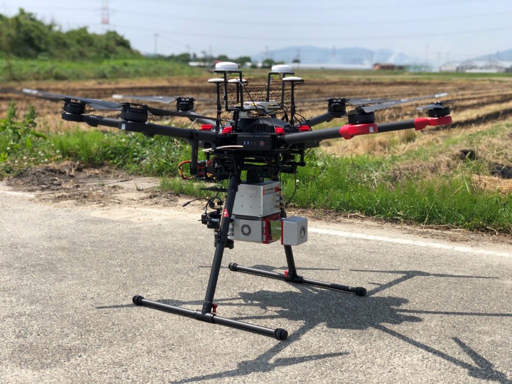
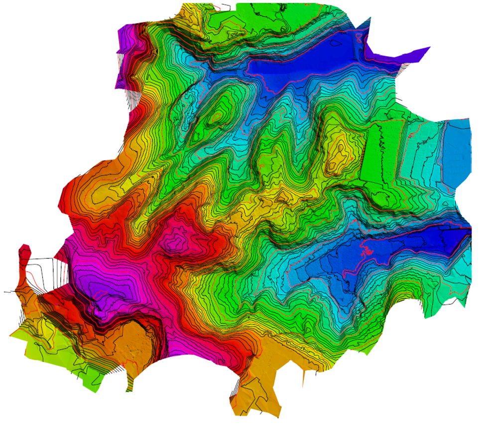
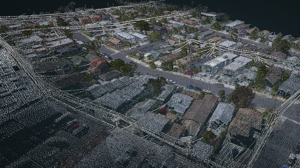
Phoenix Laser System:Laser can measure the ground surface covered with a canopy
The Phoenix ultra-compact laser that can be mounted on a drone is an cutting edge laser measurement system that makes laser measurement by Cessna planes more familiar. Now that it can be mounted on a drone, anyone can easily perform laser measurement and measure terrain where the ground surface covered with trees cannot be seen. The data measured by the laser can generate 3D point cloud data and analyze it with point cloud processing software. By using the Phoenix laser system, you can efficiently carry out conventional surveys and surveys.
Application
- Archaeological survey
- Civil engineering survey
- Forest survey
- Terrain survey
- Disaster investigation
Face recognition / biometric identification: Accurate and high-speed authentication / identification system using 3D identification engine
Face recognition system
Our face recognition system equipped with a 3D face recognition engine that realizes accurate and high-speed face recognition even when wearing a mask is attracting attention as a non-contact type entry / exit management system. The hardware cost at the time of system introduction is also relatively reasonable compared to general systems, and it is a system with high cost performance. Starting with the development of a system that uses face recognition as a sensor, we will propose a non-contact face recognition system that meets various needs.
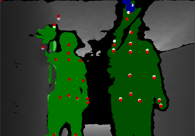
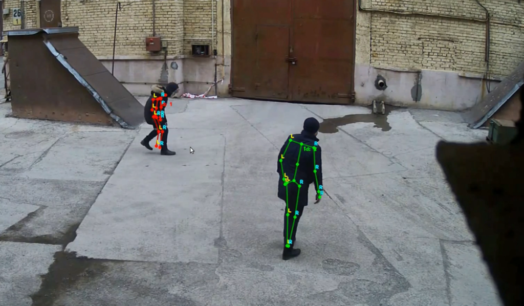
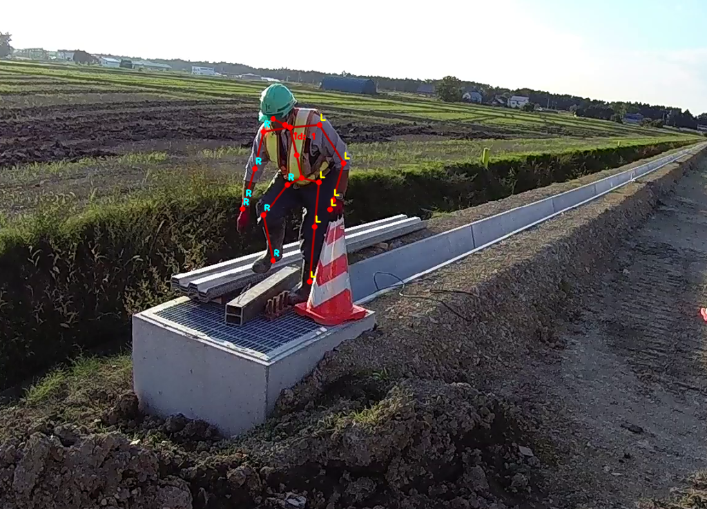
Biometric recognition system(Skeletal tracking)
Our biometric recognition system can recognize 19 points of the human body and grasp the position and orientation of each. This makes it possible to detect between left and right, and the movement of a person itself can be used as a sensor, enabling the development of a wide variety of systems. Although it depends on the purpose of use, it can be detected with high accuracy at short distances, and biometrics can be recognized in real time from 2D images when the detection distance is prioritized over accuracy.
System case
- Entry / exit management system
- Proximity detection system
- Monitoring system

Consulting
Optimal proposals that makes use of many years of experience
We will hear about the current issues, from software development to hardware selection. Utilizing more than 25 years of experience in the industry, we will propose the most suitable system for “the motto of being able to use in the field”. In recent years, as new technologies have been developed, we provide system consulting that understands the situation at the site while using the latest technologies.